
aifizgerald7749
New Member
- Joined
- Nov 3, 2018
- Messages
- 1
- Reaction score
- 0
- Points
- 0
On a recent expedition retracing some of David Carnegie's 1896 exploration from Coolgardie to Halls creek,
at 28deg12'18.24"S 121dg46'53.52"E I found these 2 bottles.
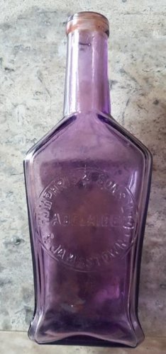
1) is labeled - Jamestown & Humphris & Sons around the edge with ADELAIDE across the middle.
it is 210mm tall and has faded purple by the sun
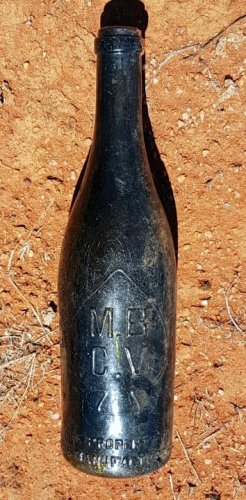
2) is the size of a champagne bottle is dark green and labeled M.B.C.V
Given that the Lands Department published a map of Carnegie's trek in Sept 1897 and
that map recorded a large quartz outcrop at this site I would hypothesis that the bottles were left by
prospectors that sunk a well and exploration shaft nearby ...perhaps as early as 1898.
Any insights about the origin and age of the bottles would be appreciated.
at 28deg12'18.24"S 121dg46'53.52"E I found these 2 bottles.
1) is labeled - Jamestown & Humphris & Sons around the edge with ADELAIDE across the middle.
it is 210mm tall and has faded purple by the sun
2) is the size of a champagne bottle is dark green and labeled M.B.C.V
Given that the Lands Department published a map of Carnegie's trek in Sept 1897 and
that map recorded a large quartz outcrop at this site I would hypothesis that the bottles were left by
prospectors that sunk a well and exploration shaft nearby ...perhaps as early as 1898.
Any insights about the origin and age of the bottles would be appreciated.

")