Steve/sewell
Well-Known Member
- Joined
- Jan 23, 2010
- Messages
- 6,108
- Reaction score
- 5
- Points
- 0
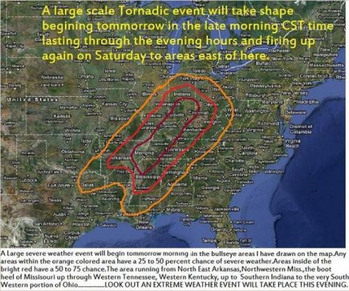
When I came home today at lunch I had warnings on my computer in the software I use (Actually I also receive text messages ) for an extreme weather event. The area in question no doubt has members of this forum living in it and I thought I would pass along this life threatening and property damaging weather event information out of genuine concern for all of you starting tomorrow morning.When using the software you can add your own percentage of thought based on prior analog years and what I have concluded is pretty close to what the National weather service is also forecasting.The only difference from mine and theirs is I start the sever weather about a 150 miles further south of the point they say it will begin.
Folks on the forum if you live in the areas I have shaded on the map below please pay particular attention to your National Weather Service Warnings and announcements Starting tomorrow morning and particularly tomorrow afternoon when the sun heats the atmosphere. On a scale of 1 to 10 with 10 being extremely likely and severe the dark red area is a solid 10 the next area outwardly bright red is a 7 to 9 and the orange colored area is a 5 to 7.
Here is what my weather software is telling me. All of the conditions and ingredients severe weather wise are coming together to make tomorrow a very high risk of occurrence for extremely dangerous,property damaging, life threatening weather.It is not a matter of if it will happen, it IS GOING TO HAPPEN,and it will also make the headlines on Saturday. This outbreak is predicted to be much larger then the one on Tuesday of this week.
This is not hype it is scary, the potential exists for more then 15 long lived Tornadoes to occur tomorrow particularly in the afternoon. Long lived means 500 miles or more in length and duration can be 5 to 6 hours. We may see an F-5 tornado before the day is over. F-5 tornadoes are one of natures most violent forces capable of wiping entire towns off of the face of the earth. It is very likely there will be a couple of F-4s also which are no picnic either. Most of the tornadoes will be in the F-2 to F-3 category.Along with the tornadoes you can expect baseball sized hail stones and straight line wind damage to occur over a good portion of all of the shaded areas. Below is the Fujita Scale.
F0 Gale tornado 40-72 mph Some damage to chimneys; breaks branches off trees; pushes over shallow-rooted trees; damages sign boards.
F1 Moderate tornado 73-112 mph The lower limit is the beginning of hurricane wind speed; peels surface off roofs; mobile homes pushed off foundations or overturned; moving autos pushed off the roads; attached garages may be destroyed.
F2 Significant tornado 113-157 mph Considerable damage. Roofs torn off frame houses; mobile homes demolished; boxcars pushed over; large trees snapped or uprooted; light object missiles generated.
F3 Severe tornado 158-206 mph Roof and some walls torn off well constructed houses; trains overturned; most trees in fores uprooted
F4 Devastating tornado 207-260 mph Well-constructed houses leveled; structures with weak foundations blown off some distance; cars thrown and large missiles generated.
F5 Incredible tornado 261-318 mph Strong frame houses lifted off foundations and carried considerable distances to disintegrate; automobile sized missiles fly through the air in excess of 100 meters; trees debarked; steel re-inforced concrete structures badly damaged.
") ]
]