Steve/sewell
Well-Known Member
- Joined
- Jan 23, 2010
- Messages
- 6,108
- Reaction score
- 5
- Points
- 0
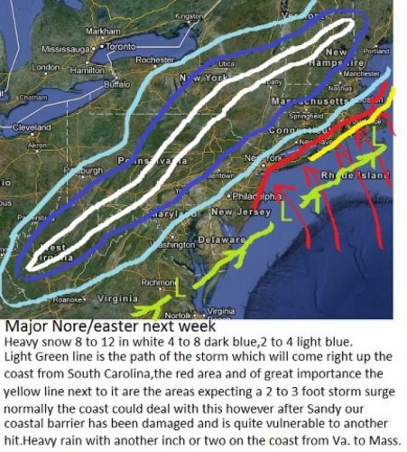
On Tuesday night Election Night a large storm is expected to be off the North Carolina coast heading towards the DElMarVa coast and strengthening into a 981 low pressure system. All of the ingredients are coming together for a large Snow Wind and rain storm from the mountains of Northern Virginia and Northern Eastern West Virgina right up the spine of the Appalachian Mountains to Maine.The higher peaks in all of these areas can expect a solid 8 to 12 inches with higher isolated amounts in the higher peaks of up to 2 feet.Heavy wind 40 to 60 mph and rain on the warm side of the storm can be expected with two to three inches of rain expected along the coast from Virginia to Massachusetts.A change over to snow is likely to the coast from New Jersey to Massachusetts as the storm goes by your area and colder air wraps in from the north west. A Shift in the track of 50 miles either way in or out can shift the snow area accordingly towards the coast or further inland at and west of the mountains.
This time around very cold air from Canada will be racing south towards the eastern United States. At the same time a storm will be gathering off the coast of South Carolina which at this time the National weather services says the storm will be pushed out to sea by the coming cold front at the jet stream levels. This is where I differ from their assessment of the likelihood of a major storm coming up the coast.The NAO blocking creates a negatively tilted trough over the eastern United States which forces storms due North and then turns them in slightly west just like it did with Hurricane Sandy.
With out the NAO blocking the storm would head north east but be well off the coast as the upper air flow of a negative or neutral NAO would would allow the storm to escape into the Atlantic as they thought Sandy would also.
The time frame of this storm is from Tues night in the North Carolina/Virginia/Maryland area off the coast of New Jersey Wednesday Evening and Thursday it should be near Massachusetts.The area that will have great concern to me is from New Jersey to Massachusetts as again a high tide and coastal vulnerability will all play key roles in bringing in the strong possibility of devastating flooding to areas already hit hard by Sandy as a two to three foot tidal surge will be able to progress much further west then normal because a lot of the Barrier Island protection dunes are gone from Sandy. Again scattered power outages through out the region more concentrated this time in the snow element of the storm will undoubtedly occur.
I hope the warning from the National National weather service is forth coming soon as with each model run I am looking at since late last evening the likely hood of a storm is now at 50 percent where yesterday at 5:00 pm it was only a 30 percent chance.The positive NAO ( North Atlantic Oscillation ) which is high pressure blocking off the coast of Greenland will be very strong at the time of the storm development. This same high pressure system was responsible for keeping Sandy from turning out to sea. Most of the National weather service had that storm turning right towards Bermuda but any good weather forecaster could see the blocking up stream that was going to enable Sandy to hug the coast and turn left at the end.
Part of the problem with the National weather forecast system is they only rely on their own data stubbornly and refuse to look at all of the other major weather services in the world to help form a better consensus.They are not always wrong by any stretch but it seems they always lag behind the other major outlets when a large weather event is about to occur.The software program I use although amateurish in comparison takes into account your own thoughts and theory's coupled with input from other major weather sources around the globe. I use,the JMA ( The Japan Meteorological Agency),The European,The Russian,and in the States here Weatherbell.com who was the only weather service along with the JMA that forecasted the track and the damage potential from Hurricane Sandy correctly from the get go.
I am not afraid to go out on a limb and would like to be proved wrong on this one but I am sounding the alarm here NOW for all of you to at least have this on your back burner of thoughts and we will see when the National weather service reacts accordingly.The NAO is expected to go neutral towards the 10th of November for a two week period which will protect the mid Atlantic and Northeast but look out around Thanksgiving for another large Nor'easter in the same area as the NAO goes very strongly positive again for a two week period. Things to think about if you live in the effected areas next week are filling up your gas tanks in you cars this weekend,and if you have wood burning capability have it ready as a fail safe.The difference from sandy this time will be how cold it is going to get during and after the storm.
Time to go to work have a good day everyone.