Steve/sewell
Well-Known Member
- Joined
- Jan 23, 2010
- Messages
- 6,108
- Reaction score
- 5
- Points
- 0
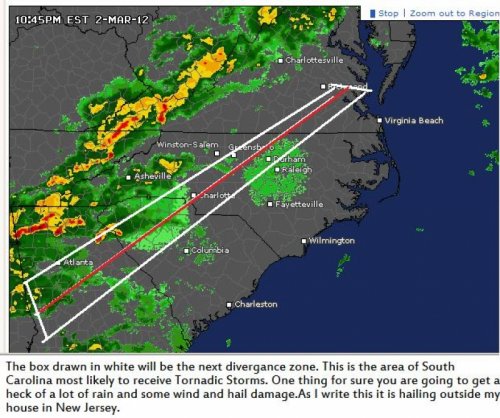
About 3 or 4am Pat in the center of the state will be where it is most active.There will be Tornadoes you can count on that. Not as many as earlier today but there will be hail and straight line wind damage. There is a part of the atmosphere which becomes very unstable it is just on the Western side flank of the Cold Front. In order for this area to become severe you need moist humid very warm air in the 5 to 10000 ft part of the atmosphere ahead of the storm system.The next clash of these two air masses will occur in your state right about here ( see picture below ) as I see temps approaching 75 degrees ahead of the front.The other feature which ignites these storms are the Mountains as the air is forced up and over the ridges tremendous down drafts occur which in themselves cause quite extensive damage plus they help to lift the warm air very quickly into that key area discussed earlier which when conditions are favorable can spawn a tornado right out of the blue.The storms will weaken as they approach North Carolina and Virginia because the air is much colder and more stable up here.