
Steve/sewell
Well-Known Member
- Joined
- Jan 23, 2010
- Messages
- 6,108
- Reaction score
- 5
- Points
- 0
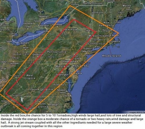
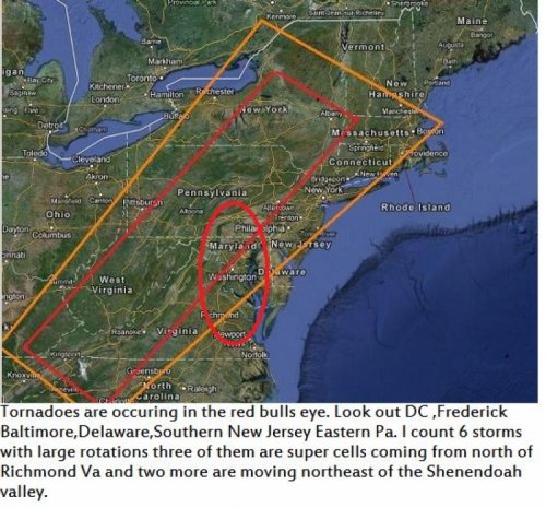
Look out in Pennsylvania,Maryland,West Virginia,Virginia,Delaware,New York State, and later the rest of New England. A strong jet stream,cold air from Canada,warm moist air racing ahead of the cold front all SPELLS big TROUBLE in the highly populated areas of the east. I would have put this out yesterday but my son graduated from High school and it was an all day affair.On this radar image the double barrel low pressure system has formed. http://www.accuweather.com/en/us/northeast/weather-radar?play=true Double barrel lows are usually associated with tornado alley not the mid Atlantic.The cold air associated with this front usually doesn't make it this far south once the month of May is upon us.This front is going to signal the change to a very cool month where June will average 4 to 5 degrees below normal. New York City and Boston will see highs only in the 50s Sunday and possibly Monday.This should bring some of the best bottle digging summer weather imaginable.......Dig them now while you can because this same area is going to have a very short Autumn and one of the COLDEST winters in the last 15 years at times rivaling the winters of 1977 and 1978 when rivers in this region froze solidly to where you could walk from Southern New jersey to Philadelphia across the Delaware river.........Be careful if you are outside today in remote areas in this region as the storms will unfold quickly.If you have smart phone capability go this link http://www.accuweather.com/en/us/northeast/weather-radar?play=true to watch for severe weather about to affect your particular area. This is a very serious event that will unfold today and catch a lot of people off guard stay safe.


 ]
]