Dallas is now getting rocked by an F-3 tornado doing a lot of damage. The storm has multiple vortices as seen in the picture.This storm is strengthing not weaking.
Here is the warning from the Severe Storm Center in Norman Oklahoma
A TORNADO WARNING REMAINS IN EFFECT UNTIL 845 PM CDT FOR DALLAS
COUNTY...
AT 834 PM CDT...STORM SPOTTERS AND DOPPLER RADAR OBSERVED A
DEVELOPING TORNADO NEAR IRVING MOVING EAST AT 35 MPH. THIS STORM IS
CAPABLE OF PRODUCING LARGE DAMAGING HAIL UP TO BASEBALL SIZE.
THE TORNADO WILL BE NEAR...
DALLAS...HIGHLAND PARK AND UNIVERSITY PARK AROUND 845 PM CDT...
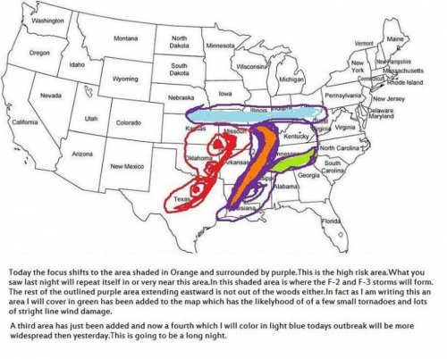
You know the drill,The area shaded in purple this time, please look out if you live in any of this area as again like yesterday a very large in numbers outbreak with at least three F-2 to F-3 Tornados WILL form this evening along with 20 to 30 F-0 to F-1 storms.Expect straight line wind damage also with large hail and frequent lightning.One thing to add I am going to put on the map where my weather program is saying there is the highest risk probability a zone colored in orange.Did any of you see the volleyball sized hail from one of last nights storms in Kansas.My best estimate for the extreme type of weather is an area along the Arkansas Tennesee Border traveling North Eastward all the way to Southern Illinois and Indiana.To any forum members please be safe that includes you Preston.As I have been writing this two more areas are under the gun.They are shaded in light green and light blue.I know the sun is out in Eastern Arkansas,North Western Mississippi,Western Tennesee and Kentucky,Southern Illinois and Southern Indiana dont be fooled it is going to turn ugly.Look at this link today.On this water vapor imagery you can see the upper low coming west getting involved today.This was not the case yesterday as all of the storm developement was from the south to North.With this low getting injected into this mess LOOK OUT.I will up my prediction to 4 to 5 long lived tornados from Eastern Arkansas Northern Mississippi,Western Tennesee and Kentucky right on up to Southern Illinois and Indiana.
Well two F-3 tornadoes have formed already in Missiouri north East Of Springfield.A tornado crossed Sedalia, Mo. around 12:30 p.m. CDT and has apparently caused major damage. The number of casualties is not known.PLEASE LOOK OUT IN EASTERN ARK ,WESTERN TENNESEE and KENTUCKY I still feel this is the area to watch later this afternoon.
A large tornado on the ground in Indiana this is a dangerous storm,as it has multiple vortices.The Wall cloud is over 10 miles in length.There are two diffrent rotations in the storm the one to the right is a F-3 large tornado with the multiple vortices the one to the left of it it almost looks attached to the one on the right is a smaller F-0.Here is the radar image out of Southern Indiana,the storm is racing North East and should impact Indianapolis in an hour.
I just received this update 6 Tornadoes repeat 6 tornadoes on the ground in Eastern Missouri!! I have ran my computer models again an have been putting in the new information at various stations in and around Missouri,Tennesee,Arkansa ect ect.The two purple colored storms one leaving North Eastern Arkansas and one slightly north of it moving in the same direction are massive F-4 tornados the kind that wipe out towns completelyIt is not a good situation more lives will be lost this evening for sure.If you live in St Charles,St Louis or the Cape Girardeau the next hour to two will be like Armegedon look at this radar loop .
You should be OK Preston most of the Severe storms should stay North and West of you.You will have to deal with some heavy rain towards tommorrow morning it looks like though.When these storms in Missouri are done it will only add enourmous amounts of water to the Mississippi and prolong the flooding.