People in Western Tennesee and Kentucky get ready,look at this radar loop in the last frames you can see the storms in Arkansas go from moving North East to a more East North east.These storms will be running into nitroglycerin type of air in these states.This would be in the 5:00 oclock Central time period.
Right now there are 5 radar indicated tornadoes with these storms in Arkansas you will here in the next hour eyewitness spotters from Arkansas telling us they can now see them.This is the most violent part of a mega outbreak the tail end picture it like a whip being flung.The storm generating all of this is almost like a Noreeaster in size.
This is an amazing shot look at this storm in the center of our country,it is almost like a hurricane on land.The thing I want you to look at is see the tongue of (orange) warm air being rotaed counter clockwise that is being shoved North Eastward from Western Arkansas Northern Mississippi,Western Tennesee and Western Kentucky watch it turn Milky grey in color at the end of the loop .This is a very bad sign as this is the developement of cold cloud tops of the super cells about to break out in this area.
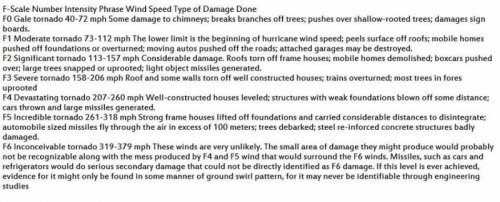
Very large Tornado on the ground North West of St Loius in this radar loop and one to the west of it just off the screen.This is an F-3.
Another Tornado has formed to the south and this one is making a B-Line for St Louis .
There are now over 50 warnings not watches WARNINGS from the Severe Storms forecast Center in Norman Oklahoma.WE are ahead of last nights pace by a lot.Yesterday at this time only 5 to 6 tornadoes had formed in Oklahoma and Kansas.Today over 10 already and there will be many more.
Two Massive Tornadoes F-4 in size rain wrapped funnels softball sized hail,10 cloud to ground lightning srtrikes per minute in each storm on the North side of Little Rock and the South Side of Little Rock.These are the two storms to really start watching as they will become more powerfull and they will spawn many more in this area to affect Tennesee and Kentucky and Mississippi..
Your a funny guy Chuck,Last update from me,this radar loop says it all if you live anywhere between Eastern Arkansas and Western Tenn,West Kentucky and north west Mississippi God help you. There are 9 Tornadoes bearing down on you.In the end my forecast has been pretty accurate.This is a really neat software plus it allows the user to plug in his own thoughts.Update two Tornadoes have popped up in Texas and one on the border of Arkansas and Mississippi this is a nasty one F-3 according to my program and it is racing North Eastward 60 miles per hour.In the radar loop it is the fastest moving storm.


") ]
]