You are using an out of date browser. It may not display this or other websites correctly.
You should upgrade or use an alternative browser.
You should upgrade or use an alternative browser.
What is this symbol ?
- Thread starter Lemon_grass
- Start date
willong
Well-Known Member
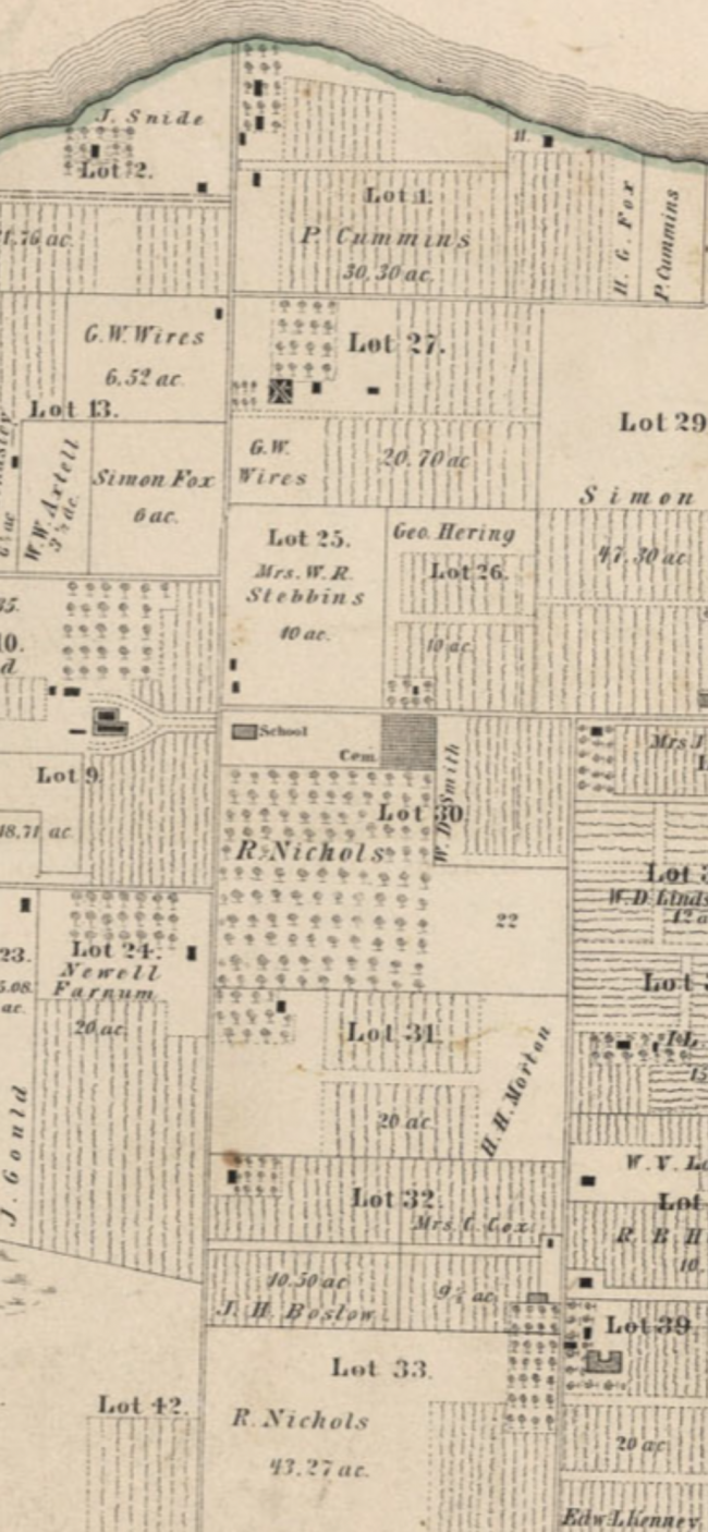
They are buildings. When not specifically identified with notations, they most often represent dwellings and outbuildings such as barns and sheds. Rural property maps such as your example would not usually depict privies, perhaps because they were not taxed "improvements."
Contrariwise, privies can often be discerned on Sanford Insurance Maps by their size relative to other structures, their (usually) square footprint and their typical location near backyard property boundaries in urban settings.
Contrariwise, privies can often be discerned on Sanford Insurance Maps by their size relative to other structures, their (usually) square footprint and their typical location near backyard property boundaries in urban settings.
willong
Well-Known Member
Depending upon the age of your map--I'm guessing 1910 or before--the plot with both a school and a cemetery (cem), if vacant and accessible today, should hold potential for collectible bottles. Inks and perhaps master inks in the privy pits of the school, and jars (from discarded flora displays) somewhere along the edges of the cemetery if there is any rough ground such as a gully, boggy area, swale or brier patch that would have been convenient for trash disposal during the turn of the 20th century era.I know privy’s were not often mentioned on maps, but any idea what these black squares are?
Added edit: That nearby shoreline to the North is definitely worth investigating, especially if it is a saltwater body with a high bluff. Indeed, if there is no evidence of dumping near the boundaries of the cemetery in such likely ground as I noted above, and if the water body is ocean, bay or marsh with a high-bank shoreline, I'd almost be willing to bet that a informal community dump was located somewhere along that shore.
Last edited:
Lemon_grass
Member
Thanks so much for the info. I was going to check those spots out too. I did locate something I thought was possibly a swamp area ( this location is an island), in the far right corner… see attachedThey are buildings. When not specifically identified with notations, they most often represent dwellings and outbuildings such as barns and sheds. Rural property maps such as your example would not usually depict privies, perhaps because they were not taxed "improvements."
Contrariwise, privies can often be discerned on Sanford Insurance Maps by their size relative to other structures, their (usually) square footprint and their typical location near backyard property boundaries in urban settings.
Depending upon the age of your map--I'm guessing 1910 or before--the plot with both a school and a cemetery (cem), if vacant and accessible today, should hold potential for collectible bottles. Inks and perhaps master inks in the privy pits of the school, and jars (from discarded flora displays) somewhere along the edges of the cemetery if there is any rough ground such as a gully, boggy area, swale or brier patch that would have been convenient for trash disposal during the turn of the 20th century era.
Added edit: That nearby shoreline to the North is definitely worth investigating, especially if it is a saltwater body with a high bluff. Indeed, if there is no evidence of dumping near the boundaries of the cemetery in such likely ground as I noted above, and if the water body is ocean, bay or marsh with a high-bank shoreline, I'd almost be willing to bet that a informal community dump was located somewhere along that shore.
Attachments
Lemon_grass
Member
They are buildings. When not specifically identified with notations, they most often represent dwellings and outbuildings such as barns and sheds. Rural property maps such as your example would not usually depict privies, perhaps because they were not taxed "improvements."
Contrariwise, privies can often be discerned on Sanford Insurance Maps by their size relative to other structures, their (usually) square footprint and their typical location near backyard property boundaries in urban settings
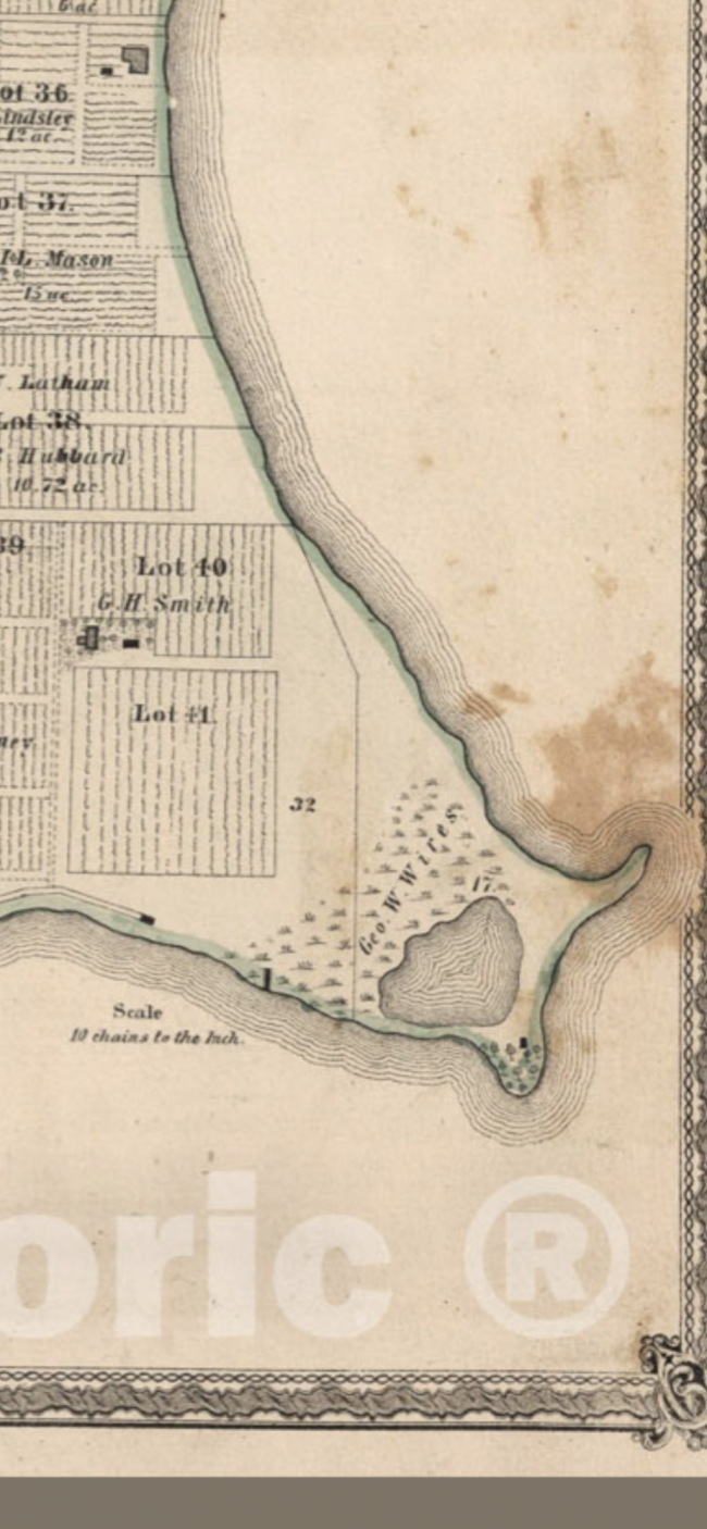
It’s an island, but it’s fresh water. Here is the north section :Depending upon the age of your map--I'm guessing 1910 or before--the plot with both a school and a cemetery (cem), if vacant and accessible today, should hold potential for collectible bottles. Inks and perhaps master inks in the privy pits of the school, and jars (from discarded flora displays) somewhere along the edges of the cemetery if there is any rough ground such as a gully, boggy area, swale or brier patch that would have been convenient for trash disposal during the turn of the 20th century era.
Added edit: That nearby shoreline to the North is definitely worth investigating, especially if it is a saltwater body with a high bluff. Indeed, if there is no evidence of dumping near the boundaries of the cemetery in such likely ground as I noted above, and if the water body is ocean, bay or marsh with a high-bank shoreline, I'd almost be willing to bet that a informal community dump was located somewhere along that shore.
Attachments
willong
Well-Known Member
Yes, I would suggest searching there if you can obtain access. That's a marsh boarding open water (at least it was at the time that the map was drawn) and seems a likely disposal site. If that pond is clean enough, you might even want to dive or snorkel there to search for bottles. If George W. Wires did not dump over a bank into the surrounding bigger water, it's a fair bet that the marsh or pond margin was his disposal area provided it was not the source of household drinking water. Those other close-by structures enhance the chances. Since the western property line of Wires' land crosses the marshy area, I think I would begin my search there--those adjacent property owners might have dumped in the same area, increasing your odds of finding something. Keep in mind that 19th century mindset often viewed such topography as wasteland. There might even have been a concerted effort to fill the marsh in order to "reclaim" the land. First thing I would do is compare current satellite imagery to historical maps to gauge if the pond contours are significantly altered or essentially the same.Thanks so much for the info. I was going to check those spots out too. I did locate something I thought was possibly a swamp area ( this location is an island), in the far right corner… see attached
Since it was right at the edge of your image cropping, I couldn't tell if there is also marsh in lot 42 of the first image (directly below name J. Gould) or if that is just a smudge on the map.
One thing that I am not familiar with is the two different hues, a dense black and a medium gray, filling the different structure icons. I suspect, especially since the school building is one of the gray variety, that the gray hue signifies an occupancy or use other than private residential. You might check with the present county assessor; or, a forum member here might know the answer.
Good luck on the hunt!
willong
Well-Known Member
People did dump in fresh water lakes too; it's just somewhat more common on saltwater as nobody would be drawing their potable water from a salty source.It’s an island, but it’s fresh water.
Fifty years ago, I had a bottle collecting friend who retrieved bottles from deep waters of Lake Crescent here on the Olympic Peninsula in WA. Dale told me that the finds were often in heaps on the bottom that indicated the residents had rowed their boats out into the lake and dumped weighted burlap sacks of trash over the side.
willong
Well-Known Member
Do you mind saying when the map was made?
Lemon_grass
Member
Wow, that’s so interesting!People did dump in fresh water lakes too; it's just somewhat more common on saltwater as nobody would be drawing their potable water from a salty source.
Fifty years ago, I had a bottle collecting friend who retrieved bottles from deep waters of Lake Crescent here on the Olympic Peninsula in WA. Dale told me that the finds were often in heaps on the bottom that indicated the residents had rowed their boats out into the lake and dumped weighted burlap sacks of trash over the side.
dab46
Well-Known Member
- Joined
- Oct 17, 2015
- Messages
- 58
- Reaction score
- 30
- Points
- 18
here in WISconsin I was told that in winter they would go out to cut ice and take a wagon of trash like old bottles dump the trash in holes that they made from cutting the ice blocks.Now you have a wagon full of ice for the ice house.People did dump in fresh water lakes too; it's just somewhat more common on saltwater as nobody would be drawing their potable water from a salty source.
Fifty years ago, I had a bottle collecting friend who retrieved bottles from deep waters of Lake Crescent here on the Olympic Peninsula in WA. Dale told me that the finds were often in heaps on the bottom that indicated the residents had rowed their boats out into the lake and dumped weighted burlap sacks of trash over the side.
Similar threads
- Replies
- 21
- Views
- 3K
- Replies
- 11
- Views
- 1K
- Replies
- 3
- Views
- 1K
Latest threads
-
-
-
-
-
-
Bayer Aspirin bottle or something else?
- Started by Mlzeigler
- Replies: 1


