Oh boy,Look out for the weekend..A Snowcane is coming

Welcome to our Antique Bottle community

Be a part of something great, join today!

Steve/sewell

Well-Known Member
Joined
Jan 23, 2010
Messages
6,108
Reaction score
5
Points
0
An event which has been seen before in our weather history is quite likely to occur again as a Category 2 hurricane with winds from 90 to 115 mph,with heavy rain ( 8 to 10 inches) and with a blizzard on its Western Flank will impact the United States coast from North Carolina to the main targets of the Hurricane New England and New York State and the heavy wet Snow in Western Maryland West Virginia,Virginia a good portion of Western Pennsylvania and Western New York.The Storm formed today in the Bahamas and all of the consensus from various weather media outlets in the world,JMA Japanese,The Euro European,NOAA United States,and private company's Weatherbell,Accuweather and my own weather software program are all starting to believe the storm is quite likely to do considerable damage to the East Coast and particularly anyone from New Jersey to Long Island to the Cape in Mass should monitor this situation.The storm will have a 930 mil low pressure reading at the time of impact.

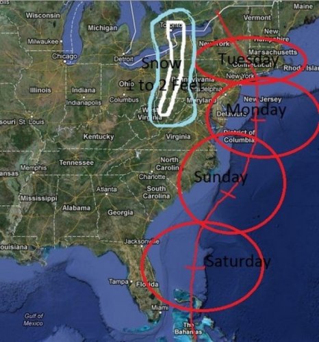
Now the other side of the storm,JOEthecrow,Penndigger,Fred,all of the New England interests who frequent this forum should be on guard for first heavy rain winds of 70 to 80 mph and then heavy wet snow. The Snow will accumulate 1 to 2 feet with isolated spots receiving more. The exact tract of the storm will come into focus by Friday night but again it is quite likely at a minimum to do considerable damage to a large area of the Coastal United States and where the eye comes ashore the usual flooding and severe wind damage will occur.This storm will no doubt bring an end to the fall foliage in the North Eastern United States. I have to get to work now as I am running late, but felt it was important enough for the members here who frequent this place to post this. Now back to your political bickering...Just keep this at arms length this week. Here is my interpretive map of the Hurricane path...Again this could shift 50 to 100 miles towards New England and change the Snow/Rain line accordingly.
This will be what we will be talking about next week!!

73A3360194F247789DEAE55560AB5004.jpg
 

Attachments

  • 73A3360194F247789DEAE55560AB5004.jpg
    73A3360194F247789DEAE55560AB5004.jpg
    117.7 KB · Views: 86

Steve/sewell

Well-Known Member
Joined
Jan 23, 2010
Messages
6,108
Reaction score
5
Points
0
What no one has any confidence in my forecast? Cowards....don't say I didn't[8D] warn ya
 

surfaceone

Well-Known Member
Joined
Dec 9, 2008
Messages
11,161
Reaction score
23
Points
0
Hey Steve,

I propose renaming in the Snowycane. That sounds ever so more kinder, winter wonderlandish. Don'tcha think?

I endorse your prognostications whole heartedly, and already have dusted off the snow shovel, and the hip waders. I hope that all you other guys are doing likewise, cuz Steve even makes Al Roker nervous in weather mapping. [8D]

Al+Roker+2011+InStyle+Warner+Brothers+Golden+hhl-k2tK6dVl.jpg
Hurricane Blues, Earl Bostic, 1945.
 

epackage

Well-Known Member
Joined
May 3, 2009
Messages
19,057
Reaction score
425
Points
83
Location
Jersey
I have seen other models where this heads to the east and we don't see much from it after sunday, I'm hoping THAT model is right Steve...[;)]
 

Steve/sewell

Well-Known Member
Joined
Jan 23, 2010
Messages
6,108
Reaction score
5
Points
0
Here she is.......... http://www.ssd.noaa.gov/PS/TROP/floaters/18L/flash-vis-short.html Meet Sandy!!!
 

Steve/sewell

Well-Known Member
Joined
Jan 23, 2010
Messages
6,108
Reaction score
5
Points
0
And if this happens....... https://twitter.com/RyanMaue/status/260814423705391104/photo/1/large there is going to be some serious damage to anything you see in red and orange on this map. Just did my latest update track still about the same except for a slight more west turn back into an area just south of Albany after it makes landfall. This is nothing to take lightly,people in rural New England could be days or weeks with out power as hurricane force winds are forecast all the way back into the mountains of Vermont and New Hampshire.
 

Steve/sewell

Well-Known Member
Joined
Jan 23, 2010
Messages
6,108
Reaction score
5
Points
0
This is the Japanese weather service forecast. https://twitter.com/BigJoeBastardi/status/260462734204870657/photo/1/large They bring the storm right over Myrtle Beach and then North West. It seems as though the storm is starting to trend more west then the NOAA forecast earlier this morning which was taking the storm North to Cape Hatteras and then abruptly turning right and heading East North east into the Atlantic sparing the areas north of North Carolina. What will be odd about this storm is it will be a cold core storm which normally isn't classified as a hurricane as it is extra-tropical. Winter Northeasters have cold cores while hurricanes in the summer and early fall have warm cores.Either way a 928 storm is nothing to sneeze at,as storms like this have the potential to unleash the following.Tornadoes on the warm sector side,heavy sustained for more then two minutes at a time,70 to 80 mph winds,Heavy rain 8 to 12 inches and very deep heavy wet snow that can bring down tree branches and collapse roofs with its weight causing severe structural damage and days without power. My track still brings the storm eye wall right over the center to just east of the center of Long Island. It is in this eye wall area 20 miles in circumference that catastrophic damage occurs.
 

RICKJJ59W

Well-Known Member
Joined
Mar 8, 2007
Messages
16,187
Reaction score
11
Points
0
Location
Lehigh Valley USA
I remember the last weird storm we had in Oct. I was working ot for two weeks clearing the streets of busted up trees. it was messed up. The $$ was good but thats about tit.
 

Steve/sewell

Well-Known Member
Joined
Jan 23, 2010
Messages
6,108
Reaction score
5
Points
0
That was known as the the Perfect Storm Rick in 1991 http://www.weather.com/blog/weather/8_20575.html as a relatively recent example but there have been others as well in 1965 and and 1957. One other factor I forgot to mention in the Long Island area a storm surge coming at a Full Moon on Monday could bring devastating flooding to Long Island and Rhode Island with gale and hurricane-force winds along the coast, as well as inland over a very large area as the storm begins to unwind; torrential rains and inland flooding.
 

Members online

Latest threads

Forum statistics

Threads
83,367
Messages
743,853
Members
24,386
Latest member
kylese
Top