Oh boy,Look out for the weekend..A Snowcane is coming

Welcome to our Antique Bottle community

Be a part of something great, join today!

epackage

Well-Known Member
Joined
May 3, 2009
Messages
19,057
Reaction score
425
Points
83
Location
Jersey
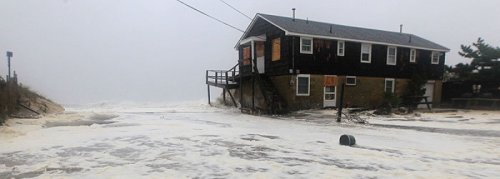
I've been watching, and while I'm happy it's not gonna hit me as hard as Irene it's sad to think of all the people who are gonna lose their homes, be injured or even worse... I'm not a religous man by any means but I'll be praying for all those people...
 

epackage

Well-Known Member
Joined
May 3, 2009
Messages
19,057
Reaction score
425
Points
83
Location
Jersey
Sadly this is a low tide pic, I don't expect this house and many like it to make it thru this storm...


0A66AB744EBD47AD96454A99588768E4.jpg
 

Attachments

  • 0A66AB744EBD47AD96454A99588768E4.jpg
    0A66AB744EBD47AD96454A99588768E4.jpg
    33 KB · Views: 83

Steve/sewell

Well-Known Member
Joined
Jan 23, 2010
Messages
6,108
Reaction score
5
Points
0
Correct Jim that house will be gone depending on where it is located.........Here is the Latest position of the storm http://www.ssd.noaa.gov/PS/TROP/floaters/18L/flash-vis-long.html it is lock and load for Southern New Jersey. It looks like the storms forward motion has increased and may be impacting Coastal New Jersey slightly before 5:00 pm. The Storm surge or lets call it what it really is (a sunami of ferocious velocity) in a small area in relative terms 15 miles 7 and and half each way of center is likely to be 12 foot in height that means one story homes in that area will have water up to their roofs. A billion dollars or more of damage is coming to that small area in less then 6 hours.For the rest of the coastal area extending up to Staten Island a 5 to 10 ft surge is coming and there too you will see total devastation. I cant stress this enough you will witness something today if you live in New Jersey that you may never see again in your lifetime. No Hurricane in the last 100 years has come in at a right angle to our state. All have come from the south and the south east never from the east completely like this one. It is going to be our Andrew and Katrina here unfortunately.
 

Steve/sewell

Well-Known Member
Joined
Jan 23, 2010
Messages
6,108
Reaction score
5
Points
0
Look at the squaw line which has developed in New York State. http://www.accuweather.com/en/us/new-york/weather-radar?play=1 Straight line 60 mph winds extending all the way up to Toronto!! No one is safe from this storm in the east!!
 

epackage

Well-Known Member
Joined
May 3, 2009
Messages
19,057
Reaction score
425
Points
83
Location
Jersey
The western side of this storm is loaded with rain but the back end seems fairly dry so I hope that helps with the cleanup and power outages being fixed sooner than later..
 

epackage

Well-Known Member
Joined
May 3, 2009
Messages
19,057
Reaction score
425
Points
83
Location
Jersey
There's gonna be alot of FREE BOATS for the taking after all the dry docks wash out, no way to save them...
 

Steve/sewell

Well-Known Member
Joined
Jan 23, 2010
Messages
6,108
Reaction score
5
Points
0
Dont be deceived Jim there is rain heading for you. The reason the storm has remained for the most part rain free on its eastern and Northern Flank is the storm in the Ohio valley which initially pulled the hurricane towards it is called an inverted , tilted or elongated trough. That storm is being absorbed by the hurricanes enormous strength as I write this. The moisture source from the upper levels of the atmosphere above the hurricane was being drained by the Ohio Valley storm.This feature has been shut off now and you will begin to see precip building on the east and north east side of the storm. I just had a wind gust of 69 mph.outside my home. Here is the latest position via satellite of Sandy which is now less then 200 miles east of Atlantic City New Jersey http://www.ssd.noaa.gov/PS/TROP/floaters/18L/flash-vis-long.html The storm is accelerating and may now make it to Atlantic City by 4:30 pm. In this satellite image Jim you can see the moisture plume in the North east quadrant of the storm loading up and aiming for your area!!!!
 

Steve/sewell

Well-Known Member
Joined
Jan 23, 2010
Messages
6,108
Reaction score
5
Points
0
News from ABC TV in Atlantic City and I quote " most if not all of Atlantic City is under water worse then in 1962" and the eye and high tide has not even come into play yet.
 

epackage

Well-Known Member
Joined
May 3, 2009
Messages
19,057
Reaction score
425
Points
83
Location
Jersey
I saw it Steve but the rain estimates I watching live now have dropped well below the expected 10+ I saw the other day, so I hope the new estimates I'm watching right now are correct...
 

Steve/sewell

Well-Known Member
Joined
Jan 23, 2010
Messages
6,108
Reaction score
5
Points
0
Look at this image http://www.ssd.noaa.gov/PS/TROP/floaters/18L/imagery/wv-animated.gif a second eye has formed!! When have you ever seen a double barrel eye before it looks like a demon staring at us here in New Jersey.
 

Members online

Latest threads

Forum statistics

Threads
83,394
Messages
744,089
Members
24,433
Latest member
Dvergatal
Top