Massive Severe weather outbreak Lower and Mid Mississippi valley starting tommorrow morning.

Welcome to our Antique Bottle community

Be a part of something great, join today!

Steve/sewell

Well-Known Member
Joined
Jan 23, 2010
Messages
6,108
Reaction score
5
Points
0
ORIGINAL: epackage


ORIGINAL: RICKJJ59W

YOU DA WEATHER MAN STEVE! [;)]


F 36-24-36[8D]

I would WRECK this chick....LOL[8D][8D][8D][8D][8D][8D]


82963B3408E04B478B1E133DBC8F4C6E.jpg
WHadd doo yuu do you mean by wreck Epackage you frighten me with such verbage.
 

Steve/sewell

Well-Known Member
Joined
Jan 23, 2010
Messages
6,108
Reaction score
5
Points
0
The sever weather outbreak is underway lookout this afternoon.began early this morning across Missouri, the Tennessee Valley and South Carolina.
A group of storms moved across central Missouri and produced numerous reports of golf ball to baseball size hail. St. Louis was hit with diameters of up to 0.50 inch.
 

Steve/sewell

Well-Known Member
Joined
Jan 23, 2010
Messages
6,108
Reaction score
5
Points
0
The storms have began and are really dangerous.Here is an image I created showing three large storms all with Tornadoes within them.

5FE0344BBBEC48ED858E1DD024336A32.jpg
 

Attachments

  • 5FE0344BBBEC48ED858E1DD024336A32.jpg
    5FE0344BBBEC48ED858E1DD024336A32.jpg
    103.5 KB · Views: 63

Steve/sewell

Well-Known Member
Joined
Jan 23, 2010
Messages
6,108
Reaction score
5
Points
0
These storms are out and out unreal This is the line of storms which will be making the headlines tonight. I hope everyone is safe from these.

780B816245024B21A9D6426CE7F6CC89.jpg
 

Attachments

  • 780B816245024B21A9D6426CE7F6CC89.jpg
    780B816245024B21A9D6426CE7F6CC89.jpg
    135.7 KB · Views: 55

Steve/sewell

Well-Known Member
Joined
Jan 23, 2010
Messages
6,108
Reaction score
5
Points
0
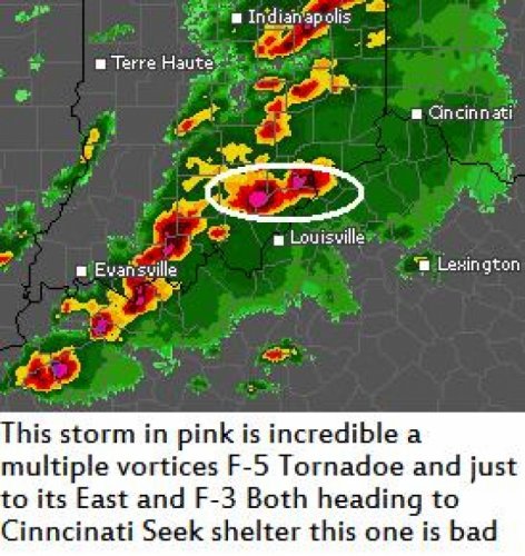
This image shows an F-5 Monster moving toward Cincinnati but it will miss by a few miles to the south Softball sized hail with this one also.Anything in its path will be no more. It has been on the ground for over 125 miles and two hours so far in time.

119654DFB14C499B9E57557E5434DB2B.jpg
 

Attachments

  • 119654DFB14C499B9E57557E5434DB2B.jpg
    119654DFB14C499B9E57557E5434DB2B.jpg
    129.2 KB · Views: 62

Steve/sewell

Well-Known Member
Joined
Jan 23, 2010
Messages
6,108
Reaction score
5
Points
0
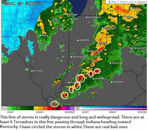
Look at this radar image live. Anything that attains a pink or light lavender color is nasty. also you can see the comma shape to the individual storms. http://www.accuweather.com/en/us/indiana/weather-radar?play=true Numerous Tornadoes,another F-4 has developed on the southern Flank heading towards Louisville, there will be complete devastation in these areas. God help them
 

Steve/sewell

Well-Known Member
Joined
Jan 23, 2010
Messages
6,108
Reaction score
5
Points
0
Look at the entire lower and middle Mississippi valleys.I count at least 25 storms with rotation in them. http://www.accuweather.com/en/us/tennessee/weather-radar?play=true
 

Steve/sewell

Well-Known Member
Joined
Jan 23, 2010
Messages
6,108
Reaction score
5
Points
0
Here is a neat picture of a two tornado storm and a baby sized trailer which will grow into a monster in a little while.

136D6A65FDE847A28D5B7C837F033ACB.jpg
 

Attachments

  • 136D6A65FDE847A28D5B7C837F033ACB.jpg
    136D6A65FDE847A28D5B7C837F033ACB.jpg
    90.5 KB · Views: 60

Steve/sewell

Well-Known Member
Joined
Jan 23, 2010
Messages
6,108
Reaction score
5
Points
0
Oh my God!! its worse then I stated yesterday!! Towns are gone completely wiped off the face of the earth!! My heart goes out to these people I hope everyone here at the bottle forum is safe. Look at these pictures Oh my God http://www.accuweather.com/en/weather-news/photos-and-videos-of-todays-to/62315
 

Members online

Latest threads

Forum statistics

Threads
83,386
Messages
744,028
Members
24,419
Latest member
angieb1229
Top